Find The Airport II
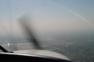
Here we go again... Okay, here's the setup, your at 3,500 feet above the terrain on approach to the airport, it is only 5 miles away. Unfortunately you are flying in the Los Angeles basin on one of those famous "hazy" days. Interesting note: most of the haze in Southern California is not caused by smog, but by moisture in the air coming from the ocean.
QUESTION: In the image below can you see the airport?

The airport is so close now that we are actually descending on long final approach. We are currently at 3,500 feet now and we must decend to 1,300, the pattern altitude for this airport. I didn't started my decent soon enough; bad form on my part. Field elevation is 296 so I've got a long way to decend. Shortly after the photo was taken I dropped full flaps (25 degrees) earlier than usual to slow my approach. Then I performed a slip for about 15-20 seconds to line up better on the PASI (precision approach slope indicator). We followed the glide-slope down to a nice landing.
This particular airport is not easy to find even when there is no haze. The entire airport facility is paved so it can easily be mistaken for an empty parking lot. This is my home airport and even I sometimes get off course trying to find the darn thing!
HINT: Here's a clue for you pilots who fly the Los Angeles basin; we are on a "modified straight in for one-niner".
ANSWER: Do you give up? Do you have the answer? Well, click here to see if you were right.


3 Comments:
Wow. How the heck are you supposed to find that? That's crazy!
GPS is a good way (my personal favorite).
If you like retro you can use a flight navigation map. If you use a map you'd know where the airport is because you can use the lakes in the foreground as reference points.
If you're instrument rated and your airplane is instrument equiped, you can use VOR navigation and an ILS.
But to be honest, finding that airport on a hazy day is always a pain for anyone who has never landed there before.
I took that picture and on first look I was ready to argue with you about your placement of the red rectangle. However, upon close inspection several times I found my ground reference that took me to the airport location.
I believe,however, that the very next frame taken within the next ~30 seconds will probably give all us blind people a slightly better chance on such a hazy day.
Am I right?, if so let us see some of the closer pictures.
Thank you. ~lrm
Post a Comment
<< Home